A 9-member team of Metta resource persons led by the Programme Director, embarked on a two-week long trip to UMa Bum/Mali-N’Mai Wa Lawng in the ‘triangle’ area, north of where the Mali Hka and N’Mai Hka rivers converge to form the Irrawaddy. This very rugged and remote region of northeastern Myanmar, has never before been set foot by any national or international non-government organization (NGO/INGO).
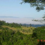
The team left Myitkyina on 15 October, 2005, going up the Mali Hka in a steel reinforced wooden boat. The boat driven by a Toyota 2L diesel engine, is strong enough to brave the strong currents in narrow defiles, and has a speed of up to 15 miles per hour up stream. It took 7 hours to reach Hpau Tung Daru, the first leg of the journey.
Seng Raw, Programme Director
Dr Lu Ja, Branch Office Coordinator
Alex La Awng, Project Officer
George La Nu, Agriculturist
 From Hpau Tung Daru the group hiked 10 miles further north to N-Gum La, a village of about 66 households, under the administration of the KIO [1] First Brigade. A cattle project coordinated by Metta is in operation at N-Gum La, and even in the farthest reaches of the area – in villages like Hkinduyang, Kum Hpang, Hting Nan, Jara Yang and N’Raw Kawng – Farmer Field Schools have been conducted by 3 of the 2000 and 2003 alumni.
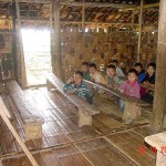
One group of resource persons conducted a 14-day Child-Centered Approach Workshop for 25 selected KIO primary school teachers at N-Gum La. Another group gave Participatory Action Research training to 25 KIO township and village administrators.
 On 18 October, the Programme Director and a small party which included a veterinarian and agriculturist, continued the journey up the Mali Hka River to visit villages in the Mali-Hkrang Wa Lawng (the area between the Mali Hka and Hkrang Hka rivers). The boat took them to Jarayang (Ningma Daru), which is as far as it could go as the big rocks and boulders in the river bed and the steep precipitous river sides make navigation and landing impossible beyond this point.
Accompanied by KIO Northern Command Secretary Wawhkyung Sin Wa, the party visited 10 villages, each having at least 20 households and within easy reach of the team’s 2-week stay. The visits involved slogging 8-10 miles on foot everyday, come rain or shine. The daily trip was accomplished in 3-4 hours at the most, quick footwork being required to avoid the legions of leeches that infest the area.
The Triangle Area is populated by Hka Hku (up-river) Kachins and some Nungs. The Hkinduyang Valley is said to have been home to the Kachin people for more than 20 generations. The Hka Hku Kachins belong to the ‘Gumlao’ or Republican type of community described by Dr. Leach in his book, Political Systems of Highland Burma: A Study of Kachin Social Structure.
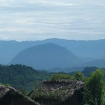
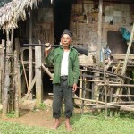
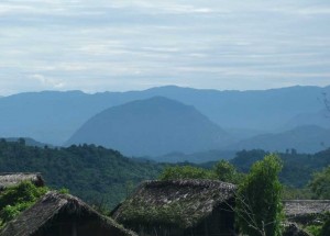
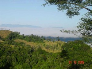
This area is part of a region considered one of the most biodiverse in the world. Its unspoiled beauty – the exotic flora and fauna, the tiers of mountains, the numerous rapids and cascades, side streams that ‘zup’ or meet with the N’Mai River, and the stretches of white sand beaches along the river banks – looks just as pristine as in the photos documented in noted ‘plant hunter’ F. Kingdon Ward’s books. Kingdon Ward made a number of visits to this area between 1914 and 1953, and the locals dubbed him “Nampan Du”, or “Flower Chief”. Interestingly enough, the team met an 87 year old man by the name of N-Nau Yaw, (old man with rifle in photo gallery), who said he worked as a porter for Kingdon Ward. He said he received one silver coin a day for his services.
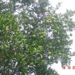
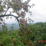
The Hkinduyang Valley is home to the hornbill and different species of other colourful birds. Black-winged, green-bodied butterflies, and other types of rare butterflies abound in the Valley. Over 20 varieties of native orchids, including ground orchids, grow abundantly near the foot paths. Flowering trees and shrubs, fruit trees such as persimmon and orange heavily laden with fruit, could also be seen along the way.
The climate is temperate and shift cultivation is practiced by everyone in the area. At least 3 varieties of paddy are grown as a major crop, with small quantities of maize, sorghum, cucumber, spices, cassava, sweet potato, and hill-beans grown along the foot paths, and pumpkin and wax gourd along the edges of the farms.
Returns from the farm rice, about 20 to 30 baskets [2], yield about 13 baskets of pounded rice. The villagers contribute about 1 basket of rice in taxes and donations to the KIO and the Church per year, to be used towards supporting local teachers and pastors [3]. This leaves most families with a shortage of about 12 baskets or 185 days’ supply of rice. Survival is mainly through borrowing from others or supplementing the rice diet with wild yams.
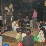
Food insufficiency and lack of medical care are the major problems challenging the people in this area. Despite such hardships the villagers, still steeped in age-old traditions of warmly welcoming visitors and newcomers, dropped by to see the Metta team on their return from the farm, offering whatever produce they had brought back with them that evening.
Livestock such as pigs, chickens, goats and cows are left free to roam. Many cattle succumb to worm diseases each year and young calves are often lost to foxes and other wild animals. In all the villages visited, veterinarian Beatrice Lu Ja and agriculturist George La Nu gave talks and practical demonstrations on basic animal husbandry and permanent farming methods.
This incredibly beautiful area is also one of the least developed regions in the country. An informal survey indicates a high infant mortality rate, and it is not uncommon to see children and adults with some form of physical disability or mental retardation.
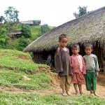
The children go about barefoot, and sanitation practices are less than satisfactory. The toilets are too far from the houses, usually in the ravines, so the children go wherever is convenient, and pigs could be seen scuttling after them to do the cleanup afterwards.
The children as well as the teachers have to spend at least one hour walking to and from school (approx. 2 miles each way). In the evenings after school, the children have to go down steep wooded ravines to fetch water using bamboo water carriers. Children as young as 6 could be seen coming to school or fetching water with an infant sibling strapped to the back. The elders rise up early in the morning at about 4 am, pound paddy for the daily meal, cook, and leave for the fields about 3 miles away, coming home only late at night.
Beginning March 2006, Metta will be conducting courses in community-managed healthcare, water and sanitation, and sustainable upland agriculture in the area.
[1] The Kachin Independence Organisation (KIO), is one of the armed ethnic minority groups that negotiated ceasefire agreements with the government.
[2] 50 baskets = about 1 metric ton.
[3] Teachers receive 20kg of rice and a viss (about 3 lbs) of salt per month to supplement their annual salary of 20,000 Myanmar Kyat (about US$ 20).